rafting Adventures
Rates & itinerary
Your Rogue River Rafting tour begins at Graves Creek and ends at Foster Bar after 3 days, 2 nights, and 38 miles of unforgettable adventures. Our adventures take you through 32 miles of the Rogue River Canyon, which is protected by the federal government. During the months of July and August, we raft the Rogue River.
Warm weather is expected this time of year, with temperatures ranging from 85 to 95 degrees. The Rogue River’s class II, III, and IV whitewater is also thrilling and safe. If the weather is too hot, don’t worry. The Rogue River’s water temperature ranges from 65 to 74 degrees Fahrenheit, making it ideal for swimming. Because the Rogue River is a drop pool river, there is a pool after each rapid.

Rafting Trip Rates 2024
3-DAY / 2-NIGHT TRIPS
- Lodge/Lodge
$1,225 per person
$1,175 per child aged 11 and younger
- Camp/Lodge
$1,225 per person
$1,175 per child aged 11 and younger
- Camp/Camp
$995 per person
$799 per child aged 11 and younger
4-DAY / 3-NIGHT TRIPS
- Lodge/Lodge/Lodge
$1,925 per person
$1,525 per child aged 11 and younger
- Camp/Lodge/Lodge
$1,525 per person
$1,400 per child aged 11 and younger
- Camp/Camp/Lodge
$1,500 per person
$1,380 per child aged 11 and younger - Camp/Camp/Camp
$1,150 per person
$995 per child aged 11 and younger
Contact Tina to book your trip by phone 888-767-3144 or email us.
Daily trips now available.
Prices based on a booking of double occupancy. For single rates, contact Tina.
5% Government use fees are included.
PLEASE NOTE: We gladly accept Visa and MasterCard, however, we charge a 3.5% transaction fee on all cards. You will be advised of this fee upfront before payment.

WHAT IS THE WEATHER CURRENTLY?
The weather is a big question sometimes in Oregon. Below is a link to what the current weather is in this area.
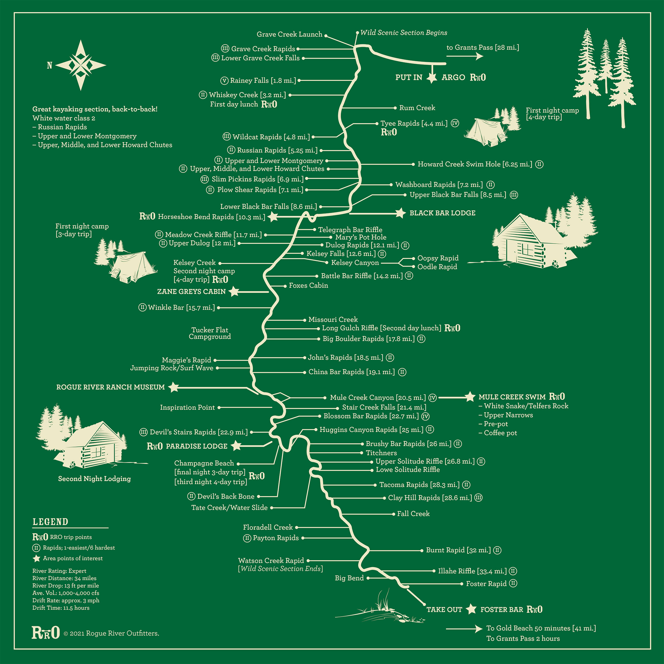
Our Itinerary Visualized
Our Rogue rafting trips are a combination of rich history, world-class rapids, and one-of-a-kind accommodations. We created our map to show the depth of the experience you will have on one of our rafting adventures. Click the map to enlarge.
Rafting Itinerary in detail
This will cover approximately 11 miles day if lodging and 13 miles day if camping.
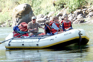
Three-day trip itinerary compared to the longer trips have a pace that is simply slower. We meet at Argo at 9:00 a.m. At this time you will meet your guides, finish packing your water bags, get fitted for a life jacket, and have a short safety speech. We are in our rafts by 10:00 a.m. and having fun.
The first three miles of the float are mild. Our first significant rapid occurs just after we enter the wild, road-less section of the Rogue at Grave Creek. The site is named for Martha Leland Crowley, who was buried here in 1846.
MILE: 1.1 Sanderson: The concrete piers visible on both sides of the river are all that remain of the bridge used for mule pack trains and foot traffic. The bridge was built in 1907 and was destroyed by flood in 1927.
MILE 1.8: Rainie Falls: The falls was named for old man Rainie, who lived in a small cabin below the falls and made his living by gaffing salmon. Guides run our boats down a narrow channel while everyone else walks around this thundering drop.
MILE 3: A quarter mile up Whiskey Creek is the Whiskey Creek cabin, a pioneer cabin recorded in the national register of historic places.
MILE 4.8: Tyee Rapids-North Bank. Tyee is the Chinook word for “chief.” Tyee Bar (South Bank) is the site of a once-famous gold mine where 300 Chinese workers took USD One Million dollars in gold dust.
MILE 5.7: Wildcat Rapids, [Class III].
MILE 5.8: Russian Rapids, [Class II]. The river narrows into a gorge with a long section of Class II rapids. Including Upper and Lower Montgomery, Upper, Middle, and Lower Howard Chutes. Great for kayaking!
MILE 6.3: Howard Creek South Side. Swimming Hole. Here we take a break and cool off in the heat of the day.
MILE 9.6: Upper and Lower Black Bar Falls. [Class III] On river left, just below lower Black Bar Falls is Black Bar Lodge, the first of several lodges along the Rogue. The lodge was built in 1932.
If you chose a Lodge trip, our first night will be at Black Bar Lodge. Black Bar is a quaint lodge nestled in the trees out of view of the river. Just the setting you would imagine for a wilderness lodge. We will arrive about 5 p.m. If you’re on a Camp trip, Horse Shoe Bend or Telegraph Bar is our first night’s camp. We arrive to a completely prepared camp, about 5 p.m. You will be amazed, it’s hard to believe they call this camping.
ON THE ROGUE RIVER, DAY TWO
After a great dinner and a wonderful night on the Rogue River, we’ll have a hearty breakfast, and head for the water. If your first night was at Black Bar, the river trip begins at 9:00 a.m. The campers have a little latter start. Once the guides break camp, we will hit the river about 10:00 a.m.
The Best Day on the Rogue River!
MILE 11.1 Horseshoe Bend: This is the location of the first night camp on a 3-day trip and because the rock across the river is harder, it forced the river to carve its channel into the adjacent softer rock, creating the tight, horseshoe-shaped curve.
MILE 12.1: Mary’s Pot Hole [Class I] or VI for Kayaks.
MILE 13.9: Kelsey Canyon (named after Captain John Kelsey) another great series of Class II Rapids.
- Upper Dulog Rapid
- Oopsy Rapid
- Oodle Rapid
- Kelsey Falls
MILE 16.6: Battle Bar Campsite and Historical Site. A major battle during the 1850s between the US Cavalry and a band of locals Indians was fought here. The Bob Fox cabin is visible on the left bank. The cabin was built in the 1920s and partially destroyed in the 1964 flood.
MILE 17.5: Winkle Bar. This is the site of Zane Grey’s cabin. Grey purchased this mining claim from a gold prospector in 1926.
MILE 19.5: Quail Creek. A fire of close to 3,000 acres burned here in 1970.
After many rapids, Zane Grey’s cabin, swimming through lower Kelsey Canyon, and other possible side hikes, we arrive around 12:30 p.m. for day-two lunch at Missouri Creek.
Now that your lunch has settled, we can stop at the jumping rock. It’s a rock for all comers; 5″, 10″, and 15″ feet landing in a deep pool. Next is the surf wave a play hole the rafts and kayaks can enjoy.
MILE 21.3: John’s Rapids. [Class II] Named after Chief John, one of the leaders of the Indian tribes during the 1850’s war with the US Calvary.
MILE 23: Rogue River Ranch and Mule Creek. Site of a historic, restored ranch. We usually spend a while here, exploring the ranch and swimming at the swimming hole in Mule Creek.
MILE 23.5: Mule Creek Canyon. [Class IV] A beautiful, narrow canyon formed as the river carves a path along a fault line. One mile of fast active white water with rapids in the canyon including:
- Entrance (Jaws or Guardian Rocks)
- White Snake
- Telfers Rock
- Upper Narrows
- Pre-Pot
MILE 25.5: Coffeepot. A churning semi-whirlpool, two miles from the beginning of Mule Creek Canyon. The river bounces off the canyon walls creating diagonal waves and tricky currents. This is the narrowest passage on the river.
One highlight of our trip is next. In the heat of the day, we take the World-Famous Mule Creek Canyon Swim… then it is on to Blossom Bar!
MILE 27.1: Blossom Bar Rapids. The Rogue’s most famous rapids, named after the Wild Azaleas that bloom here in the Spring. River pioneer, Glen Woolridge, blasted a passage through these rapids using dynamite sunk in a weighted burlap sack.
After Blossom Bar, one more rapid to swim, the Lower Stair, then it is off to Paradise Lodge. We will arrive about 5:00 p.m.
Paradise Lodge sits just above the river. From the deck, you can watch the river peacefully flow by. From your beautiful rooms, you will have a great view of the Devils Backbone. There is a lot to see and do at Paradise Lodge. Camping? Just below Paradise Lodge is Champagne Beach Camp. It’s a beautiful place to spend our second night under the stars.
ON THE ROGUE RIVER, DAY THREE!
After a great night and a wonderful breakfast, whether at camp or at the lodge, we are back in the boats at 9:30 a.m. We have 12 miles today and the fun is not over. Our first rapid is the Devils Back Bone and then comes the peace and quiet of Huggins Canyon.
MILE 29: Huggins Canyon. This section of the Rogue was named by Glen Wooldridge after a local hunter, Andy Huggins. Huggins lived for many years at Half Moon Bar, where his grave is located.
MILE 31.0: East Creek – South Bank. This is the site of the former “General’s Cabin” owned by Generals Eakers, Spaatz, LeMay, Anderson, and Twining. The land was sold to the group by Wooldridge as a former mining claim.
MILE 31.7: Solitude Rapid. This location bustled with mining activity around 1900.
MILE 32.9: “Take Creek Water Slide.” We will make a quick stop just after Huggins Canyon. Here is the World Famous “Take Creek Water Slide.” It requires a bit of a hike and a bit of a climb. But one time through, the chute makes it all worthwhile. Hang on and enjoy this natural slide!
MILE 33.0: Tacoma Rapids. Named after a mining operation from Tacoma, Washington. Extensive mining was done in this area early in the century.
MILE 33.2: Clay Hill Rapid and Lodge (private lodge, reservations required). An original homesite is still intact up the creek. An old sawmill was also on the creek. This area is private property; please respect the owner’s privacy. Hathaway Jones’ wife, Flora Dell Thomas, was born here. Hathaway Jones (1870-1937) was a local packer, mail carrier, and storyteller.
MILE 34.8: Flora Dell Creek. The creek is named after Flora Dell Thomas, Hathaway Jones’ wife. Flora Dell Creek plunges over a 30-foot sheer wall into a deep trailside pool.
MILE 37.7: Watson Creek. Here are the remains of Buster Billings’ cabin. This is also the End of The Wild & Scenic Section of the Rogue River!
MILE 40.0: Foster Bar/Foster Creek. Named after Charles Foster, miner, packer, and lieutenant in the military during the Indian Wars. Foster escaped an Indian attack at this site and worked his way downriver to Port Orford (then Fort Orford). After the Indian Wars, Foster returned to settle in this area and married Catherine (a Karok Indian).
This is our takeout point. Your vehicle or shuttle van will meet us here.
From Foster Bar you could travel back to Grants Pass (2-hour drive) for one more night there. Or head to Gold Beach on Oregon’s beautiful coast less than an hour away.